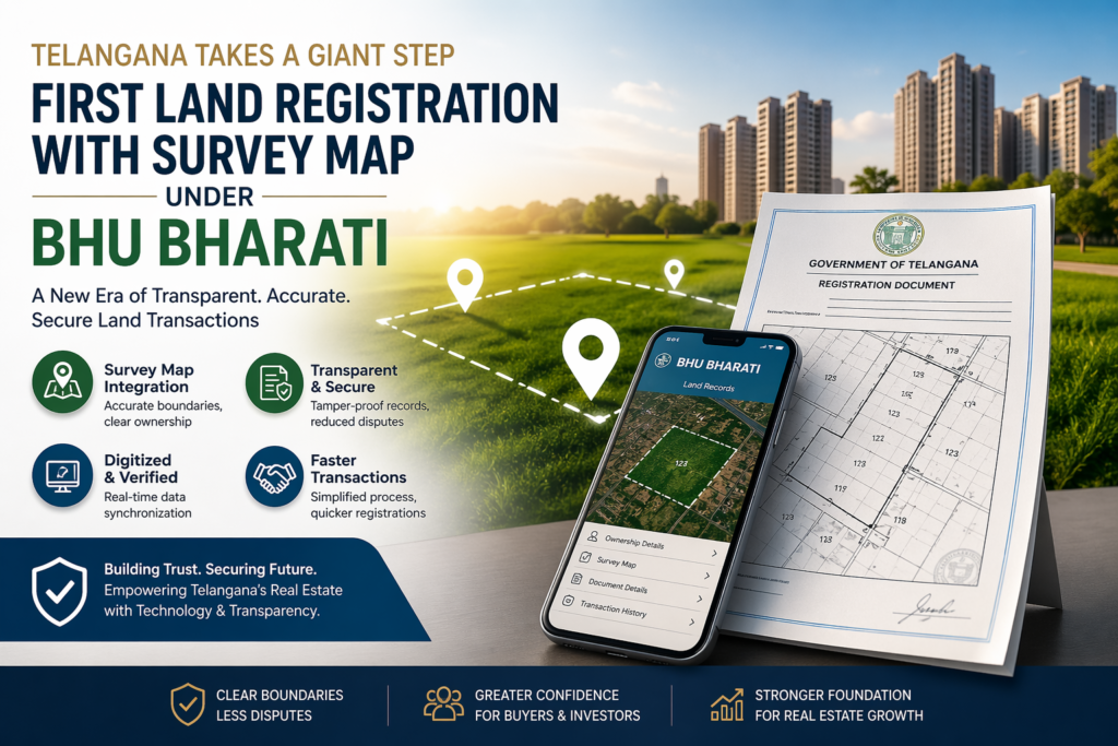
A New Era of Transparent & Dispute-Free Property Transactions
In a landmark reform for land governance, the Telangana government has successfully completed its first-ever land registration integrated with an official survey map under the newly introduced Bhu Bharati system. This move marks a significant step toward transparent, accurate, and legally secure land transactions in the state.
What is Bhu Bharati?
Bhu Bharati is a next-generation Integrated Land Records Management System (ILRMS) introduced under the Record of Rights in Land Act, 2025. It replaces older land management systems by integrating:
- Land registration
- Survey and mapping
- Record of Rights (ROR)
- Mutation services
into a single unified digital platform.
Each land parcel is assigned a unique digital identity (Bhudhaar number) linked with geo-referenced mapping, ensuring accurate ownership records and eliminating duplication or fraud.
Historic First Registration with Survey Map
The first registration under this system was completed in Kusumanchi mandal of Khammam district, marking a major milestone in Telangana’s land reforms.
Key Highlights:
- Registration completed with an official survey map showing exact boundaries
- Assignment of a unique Bhudhaar ID
- Integration of survey, mapping, and registration in a single workflow
This ensures that what is documented legally matches the actual land on the ground, eliminating long-standing ambiguities in ownership.
Why Survey Map Integration is a Game-Changer
Traditionally, land registrations relied on survey numbers and textual descriptions, often leading to:
- Boundary disputes
- Encroachments
- Multiple ownership claims
With Bhu Bharati, registrations now include digitally verified cadastral maps, offering:
1. Precise Land Boundaries
Geo-referenced maps clearly define property limits using advanced mapping technologies.
2. Reduced Legal Disputes
Accurate spatial data significantly minimizes land-related conflicts.
3. Fraud Prevention
Unique land IDs prevent duplicate registrations and title manipulation.
4. Increased Buyer Confidence
Buyers can verify land authenticity before investing.
Pilot Implementation Across the State
The system is currently being implemented on a pilot basis in select mandals, including:
- Kosgi
- Kusumanchi
- Aswaraopeta
- Amangal
- Vatpalli
Based on the success of this phase, the government plans to expand Bhu Bharati across the entire state.
Mandatory Survey Mapping for Future Registrations
Under the new framework:
- Survey maps are becoming mandatory for land registration
- Land parcels must undergo multi-level verification surveys
- A Land Parcel Map (LPM) linked with geo-coordinates is required
This ensures that all future transactions are aligned with actual ground realities rather than outdated records.
Technology Driving the Transformation
Bhu Bharati leverages modern technologies such as:
- GIS-based mapping systems
- Drone and rover-based land surveys
- GPS-linked parcel identification
- Real-time digital dashboards
Large-scale surveys are being planned to create accurate digital land maps across hundreds of villages.
Key Benefits for Real Estate Stakeholders
For Buyers:
- Clear ownership verification
- Reduced legal risks
- Faster and more reliable registration
For Sellers:
- Enhanced asset credibility
- Smoother transaction processes
For Investors:
- Improved transparency
- Better valuation confidence
- Long-term asset security
Challenges & Initial Observations
As with any major reform, the early phase has seen some challenges:
- Temporary technical issues
- Requirement for trained survey personnel
- Transition adjustments from legacy systems
These are expected to be resolved as the system stabilizes and scales.
Impact on the Future of Real Estate
The introduction of survey map–based registration signals a major transformation in land governance. It aligns Telangana with global standards where:
- Every property is digitally mapped
- Ownership is spatially verified
- Transactions are transparent and tamper-proof
This is expected to drive:
- Higher investor confidence
- Increased transaction volumes
- Significant reduction in land disputes
Final Thoughts
The rollout of land registration with survey maps under Bhu Bharati is more than just a policy upgrade—it is a structural shift in how land is owned, verified, and transacted.
As implementation expands, it will create a secure, transparent, and future-ready real estate ecosystem, benefiting buyers, investors, and landowners alike.